 The sun had hidden itself away again by the time we arrived at Anacortes. We pedaled through light rain at times along a road that climbed and dipped amongst evergreens. Around mid-morning, we arrived at Discovery Pass between Anacortes and Whidbey Island. The sun came out and the ground seemed to steam. The place was incredible. There was a significant current going through because of the tide, the 1930's bridge provided a strangely elegant contrast and a large sea lion added to the sense of wonder. Alas, I had thought the sea lion was a log for a bit, only to have it submerge just after I realized that it was, in fact, an animal and that it might make a wonderful photograph. I was not quick enough on the draw with my old Minolta SLR. Instead, I had to make do with this shot.
 While my SLR does take good photos, I began to recognize its limitations compared to digital cameras. For one thing, it was significantly heavier that Margo and Chris' camera. As well, you could know instantly whether you got the shot, or whether you needed to take another shot. And as you are less likely to take another shot with a film camera, you might not take another. As a case in point, I submit to you this shot.
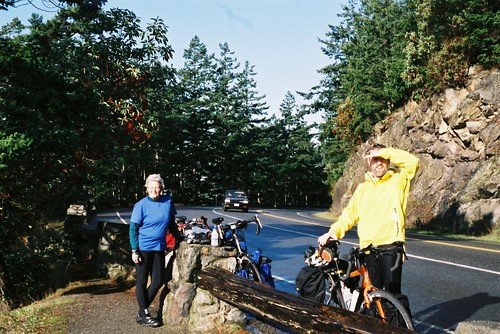 I had asked Chris to take off his helmet so I could take a photo. Only, as I took the shot, he shaded his eyes from the sun! To be fair to Chris, his eyes are rather sensitive to light.
We crossed the bridge to Whidbey Island. As was becoming our custom, we hit the stand of tourist information to find a local map of the place before heading on. We rolled on with a question of navigation unresolved. At least one of our maps showed that there was a road running down the western side of the island, that was very close to the sea and therefore likely to be very scenic. However, because it was in Whidbey Island Naval Air Station (or N.A.S.), i.e. a U.S. Navy airport, it was not clear whether the road was open to the public. Fortunately, the detour to find out if it was, was quite short, more so because once we saw the gate was quite firmly closed and unmanned, we didn't have to bother explaining to the U.S. Navy why a trio of hippy-ish (two with beards) Canadians wanted to access the base.
The runway of the N.A.S. ran East-West across Whidbey Island, so the road we rode South on took a significant jog to the East. For an aviation buff like myself, it was a rather fun ride as that seemed to be touch-and-go landing practice day for the aircraft based at the N.A.S. They were mostly Orion maritime patrol aircraft, a type of plane for which I have certain fondness. Evidence suggests the locals have mixed feelings about the airfield as one of the streets nearby was called Noisey Circle. Actually, I think this is more wry humour rather than a serious complaint.
We stopped for a rather late lunch in Coupeville. It consisted of some delicious seafood chowder accompanied with some yummy, freshly baked bread. The place we were eating in was a bakery cum restaurant perched on the edge of a horribly scenic bay in a devastatingly quaint old building.
We pressed on through the afternoon until we arrived at the ferry terminal for Port Townsend, our intended stop for the night. As luck would have it, we had to wait for about an hour for the ferry. It was luck indeed as very close to the ferry terminal was Fort Casey State Park. This was interesting for a number of reasons. Fort Casey was coastal defense battery built in the late 19th and very early 20th century. It featured a number of 10 inch guns on disappearing mounts. Really rather impressive. I had read about such guns, but had never seen, or even heard of such large ones. The question was asked against why these defenses were built and against whom. I pointed out that the location was a natural choke point at the entry to Puget Sound, the best U.S. harbour north of San Francisco. Against whom? Well, no one would likely have been publicly specified, but given that we were very close to Esquimalt, then the Royal Navy's main base in that part of the world and that the Royal Navy was the largest naval power of the time, to me it was obviously that the British (which included us Canadians at the time) were the likeliest of potential adversaries.
 The assorted observation platforms and the like allowed us a very good view of the Olympic Peninsula across the inlet. While we watched, we were in turn being watched by a trio a of Columbian black tail deer, likely a doe and two fauns.
 We caught the ferry to Port Townsend, arriving after dark. At the motel that night we worked out the next day's trip. Unlike the previous two days, when we only done a little more than 60 km each day, if we were to make the ferry to Victoria from Port Angeles, we would have to ride 75 km before 2 PM. Not insurmountable but still no mean feat. Especially as the weather turned nasty during the night.
I bless the fact that I had bought new rain pants while in Vancouver and had spent a certain amount of time and money reviving my Gore-Tex jacket. It was wet. Very wet. About the only good thing you can say about the rain was that it discouraged us from stopping to admire the view.
 (This photo stop was one of exceptions. It was done for what should considered as a remarkably obscure reason. Robin Hill is the name of the summer house in North Hatley that Margo co-owns along with my mother and my uncle. It has been in the family for nearly a hundred years.)
Of course the rain also hindered us from stopping period with all the water on trail and our brakes. Part of our route was on the Olympic Discovery Trail. This is quite a nice bike path, though in a few spots, it was obvious that bikes were not front and center in the designers' minds with steep downhills followed by sharp turns. Still, we made the ferry and then devoured the ferry company's chili like a pack of hungry stoats.
 The rain made the use of electronic equipment tricky as when my odometer got too wet, it would cease to register my progress. In addition, the plastic baggy that held Margo's cell phone wasn't as waterproof as we would have wished: she had trouble alerting her son John about our arrival in Victoria. In the event, we managed to give John prior warning of our specific arrival (he'd had a general warning several days earlier) before we arrived at his apartment in Victoria.
The apartment John lived in had previously been the residence of my eldest brother, Stephen. This was not a coincidence: John had moved in as Stephen moved out. I was amused by the fact that it was distinctly tidier on my visit with Margo and Chris than it had been two years earlier when I had stayed during Stephen's tenure. Then again, one tidies up more aggressively for one's parents than for one's siblings. From John's apartment, I made my way to Stephen and his wife, Margaret's apartment.
That night, Margo, Chris, Stephen, Margaret, John, his girlfriend (whose name I've unfortunately forgotten) and I celebrated the end of our trip and Margo's birthday. We made a somewhat unruly and disparate mob of people as we bussed around Victoria going to two restaurants and a supermarket. Still, we had fun. While we were a somewhat unruly and disparate mob of people, we also a somewhat unruly and disparate mob of good-humoured and good-natured people.
Looking back on the trip, I realized that my worries about my endurance were remarkably silly given that I fairly consistently outpaced Margo and Chris. The latter told me that the telltale day was the third one as that is the day that fatigue tends to peak. On that day, I had been wet but otherwise okay. More importantly, I was now utterly hooked on cycle-touring!
Hence this blog.
No comments:
Post a Comment